Take a Hike!

Hiking the Smokies
Millions of visitors to the Smokies experience the park from the comfort of their cars, driving its winding roads, stopping only occasionally at a scenic roadside pull-off to take a few pictures, or perhaps enjoy lunch at one of the wooded picnic areas. Others venture into the forest for a short hike along a quiet walkway or one of the more accessible trails. But the best way to experience the park is on foot, following the well-maintained hiking trails to explore some of the more remote areas.
There are over 800 miles of hiking trails in the Great Smoky Mountains, ranging widely in accessibility and difficulty. Some of the most die-hard trekkers in the eastern U.S. pass through the park on the 71.4 miles of the Appalachian Trail that winds its way through spectacular scenery along GSMNP mountain ridges, including the AT’s highest peak, Clingmans Dome. Regardless of your physical condition, you will undoubtedly find a trail that suits your desire to explore the natural beauty of the Smokies. Many trailheads can be found on the roads throughout the park, with convenient parking areas. Some popular trails quickly exceed the available parking during the height of tourist season, so anyone wishing to hike one of these trails should plan to arrive early, before the crowds. Early arrival provides the added benefit of enjoying nature in relative solitude, as some trails can become as crowded as the streets of downtown Gatlinburg during the summer months!
The owners of Happy Bear’s Hideaway enjoy the outdoors immensely, and their love of the Smokies is the main reason they chose to buy (and then rebuild) their vacation home here. They have hiked over 500 miles of trails during their numerous stays, and continue to find new and exciting experiences with every trek. They hope that guests at their cabin take advantage of the opportunity to explore their favorite trails, some of which are described on this website.
Trail Guides
Before embarking on a hike anywhere in the Smokies, I would strongly recommend getting a trail guide, and doing some research. There is nothing worse than starting down a trail, hiking for an hour, turning around and heading back, and then finding out that if you had kept going for another ten minutes, you would have been treated to a breathtaking scenic view or marvelous cascading waterfall. Numerous books have been written about hiking in the Smokies. Some of these focus on specific types of hikes (day hikes, waterfall hikes, historic hikes, etc.), and others are more general. Some are lavishly illustrated with photographs, while others focus on technical aspects of each hike (elevation gain, botanical species which may be observed, etc.) Your selection of a trail guide is very dependent on your specific interests, and what you want to get out of your hike. For this reason, I would recommend flipping through a few at your local bookstore (or virtually on Amazon), and picking the one that suits your desires.
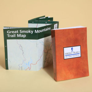
If I had to pick one and only one hiking guide, it would be Hiking Trails of the Smokies, published by the Great Smoky Mountains Association (GSMA), often referred to as the “little brown book.” This comprehensive guide sells for around $21 in all of the official visitor centers in the park, as well as online on the GSMA website (and Amazon!) This book includes a description of every official trail in the park, and provides elevation profile charts, as well as mile-by-mile discussion of the highlights of each trail by local experts. This well thought-out book is sized to fit easily into your backpack or the pocket of your cargo pants, and includes a folded map of the park inside the back cover. In addition to its trail descriptions, the book is also chock full of useful information for the Smokies hiker, including advice on water treatment, waste disposal, first aid, and of course, what do to when one encounters a bear. The trail descriptions tend to be relatively terse, compared to some of the other trail guides, and there are no photographs of beautiful scenery to accompany the narrative… you just have to use your imagination! But whereas other books tend to describe only a limited number of trails, including include only those which the author considers to be the most scenic, historic, or whatever, Hiking Trails of the Smokies includes all of them. Additionally, while most guides group their trail descriptions by geographic regions of the park, this book list them in alphabetical order (from Abrams Falls to Wolf Ridge).
Maps & Apps
In addition to a trail guide, it is worthwhile to invest in a Great Smoky Mountains Trail Map. The map included with the book described above is available for purchase at any of the GSMNP gift shops for $1.00. The same map can also be downloaded as a PDF file from the official National Park Service website at https://www.nps.gov/grsm/planyourvisit/upload/GSMNP-Map_JUNE14-complete4-2.pdf.
This is a nice overview of the park, showing the relative location of each trail, but lacks the detail necessary for planning a serious hike. There is no elevation information, and the scale does not allow for the realistic depiction of the sinuous trail courses necessitated by the mountainous terrain. For those genuinely interested in exploring the park on foot, it is almost essential to obtain a larger-scale trail map. In this regard, I would recommend the 1:40,000 Trails Illustrated series published by National Geographic. For complete coverage of the park, two maps are required: #316, Cades Cove – Elkmont, and #317, Clingmans Dome – Cataloochee, which cover the western and eastern halves of the park, respectively. The maps are printed on a plastic coated material which is resistant to moisture and tearing. Each map is two-sided, dividing its total area of coverage into western and eastern halves. Contour lines show the terrain elevation, and the scale permits many more natural features to be shown.
Smartphone apps are also available, facilitating the use of the phone’s GPS capability to pinpoint one’s location, in real time, on a digital map. Chimani, LLC, produces a series of topographic map apps covering many national parks, including the GSMNP, which I particularly like. Available in both Android and Apple versions, this is a handy complement to a hardcopy map. Note that I said complement, not substitute. I would not recommend relying on an app as your only tool, for one simple reason: in the event that your phone battery should die, without a paper map as backup, you would be left without any map at all. There is no place to recharge your phone in the woods!
Popular Hikes
Laurel Falls Trail
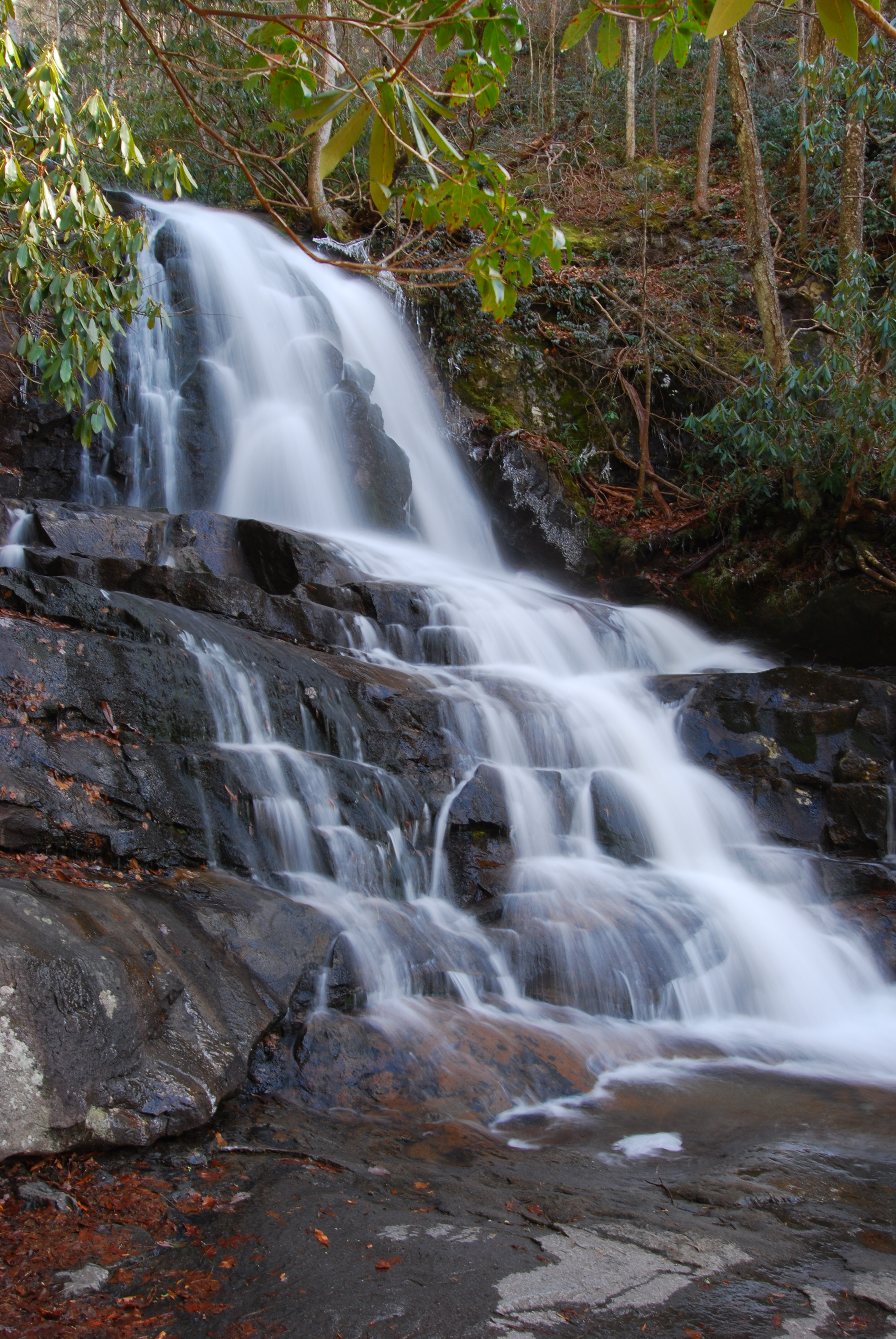
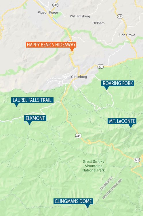
For those who wish to experience the Smokies on foot but are not regular hikers, a good “starter trail” is the Laurel Falls trail, which is located on Little River Road 3.7 miles west of the Sugarlands Visitor Center. This is a very popular trail due to its close proximity to Gatlinburg, as well as its relatively short length, and the spectacular waterfall which awaits at the far end. It’s a short 1.2 mile walk to the falls, the trail gradually climbing 300 feet in elevation over that distance. The trail to Laurel Falls is ideal for families with young children, due to its short length, easy climb, and promise of beautiful scenery at the falls. For those who are more adventurous, the trail continues uphill for another 3 miles past the falls, eventually joining the Cove Mountain trail. Once past the falls, the number of hikers using the trail decreases dramatically. The atmosphere of solitude which begins at this point creates a striking contrast to the busier section of the trail encountered earlier.
Parking at the trailhead can be limited, especially during weekends during the busy months. The small lot fills quickly, causing visitors to park along the roadway for as much as a half-mile in each direction from the trailhead. While the park service allows this, people should be very careful when hiking along the roadway to and from their cars, due to the traffic on Little River Road, which can be heavy at times.

Cherokee Orchard and Roaring Fork
Some of the most popular hikes in the park are easily reached from downtown Gatlinburg. One starts on the Historic Nature Trail, which joins the Parkway at traffic light #8. Up the hill past the convention center, Space Needle, and numerous motels, the road joins Cherokee Orchard Road and proceeds into the park. Just past the Noah “Bud” Ogle cabin, the road splits into a single-lane loop. Along the loop can be found trailheads for the Trillium Gap, Bull Head, and Rainbow Falls trails, all of which lead to Mt. LeConte. Midway around the loop the is the beginning of the Roaring Fork Motor Nature Trail, which is open only in the late Spring, Summer, and early Autumn months. This road parallels the Trillium Gap trail, and provides another access point for hikers going to Mt. LeConte. The Baskins Creek trail cuts across the loop, forming two trailheads on the same road.
The Motor Nature Trail passes numerous historic structures as it continues one-way back to Gatlinburg, ending on the East Parkway just north of downtown. A noteworthy stop along the roadway is the “Place of a Thousand Drips,” where a multitude of diminutive cascades descend independently from the rocks above, joining to form a small tributary feeding the Roaring Fork.


Mount LeConte
A favorite destination of hikers is Mt. LeConte, the third-highest peak in the park. At an elevation of 6,593 feet, it is surpassed only by Clingmans Dome and Mount Guyot.
Mt. LeConte has the distinction of being the home of the only lodging inside the park other than campsites, LeConte Lodge, which is accessible only by hiking one of the five trails up the mountain. Its absence of electricity makes staying at LeConte Lodge a unique overnight experience. Oil lamps are the only source of light after dark, as they have been since the lodge’s construction nearly a century ago. The rustic cabins are heated by propane wall heaters, which are greatly appreciated during the cold nights experienced at this elevation, even in the summer months. Meals are served family-style in a dining hall, and the office/recreation building is equipped with board games, a library of historic books by local authors, and assorted musical instruments for entertainment. Staying at the lodge is actually rather expensive, but LeConte is almost always sold out during its open season. Due to the high demand, reservations are not first-come/first-served, but are selected by lottery each fall. Visit the LeConte Lodge website, http://www.lecontelodge.com/, for more information on this one-of-a-kind vacation experience.
Getting to the top of Mt. LeConte can be exhausting, exhilarating, or both. Hikes range from 5 to 8 miles in length, and all of the trails to the top feature breathtaking scenery. The five routes to the top – Alum Cave Bluffs, Rainbow Falls, Bullhead, Trillium Gap, and Appalachian/Boulevard trails – begin on either the Roaring Fork Motor Nature Trail or Newfound Gap Road. Several times each week, a llama pack travels up and down the Trillium Gap Trail to restock the lodge with food, linens, and other supplies. Llamas are used, rather than horses, because they cause less damage to the trail. If you choose to hike LeConte via this route on the right day of the week, you may encounter these creatures during your journey.

Clingmans Dome
Another must-see for the first time Smokies visitor is Clingmans Dome, the highest peak in the National Park, at an elevation of 6,643 feet. Clingmans Dome lies on the Tennessee-North Carolina border, and is accessed via a seven mile spur off US 441, just south of Newfound Gap (closed in winter). The road ends at a large parking area, at which one can find restrooms and a gift shop, as well as the trailhead up to the observation tower at the peak. The half-mile trail is paved, but moderately steep, climbing approximately 400 feet in elevation over its short length. At the top, a spiral ramp takes one to the top of the tower’s observation platform, which provides a panoramic view of the Smokies. On a clear day, visibility can be as far as 100 miles.
Ascending Clingman’s Dome, the trail intersects the Appalachian Trail, which extends 2,184 miles from Springer Mountain, Georgia, to Mount Katahdin, Maine. Several hundred hardy individuals complete this entire length each year, hiking from the spring through fall months. Notably, this is the highest elevation that these individuals, known as through-hikers, will encounter over their entire journey.
Elkmont
For history buffs, the site which was once home to the town of Elkmont provides a snapshot of life in the Smokies prior to the establishment of the National Park, and how people continued to live in the park even into the 1970s. The facility which currently comprises the Elkmont Campground was, in fact, a thriving community in the era when logging was active in the region, at the turn of the twentieth century. Later, it became a resort area, with the construction of the Wonderland Hotel in the 1910s. The Appalachian Club and Wonderland Club were formed by businessmen from Knoxville, who built vacation homes in neighborhoods with the names of Millionaire’s Row, Society Hill, and Daisy Town.
Remnants of these summer resorts still exist. Due to years of neglect, many of these homes were beyond repair, and had to be razed in the last few years. Chimneys and fireplaces are all that remain of these structures. Other houses in better condition were preserved, and provide a glimpse of the vacation community which once existed here. Two of the larger buildings, the Appalachian Clubhouse and Spence Cabin, have been fully renovated and are available for day use rental.
Fireflies
For two weeks in early June, Elkmont is also the home to one of the park’s more extraordinary species, the Synchronous Firefly, Photinus Carolinus. These insects exhibit the unusual behavior of flashing in unison about a half-dozen times, going dark all at once, and then repeating the cycle. Hundreds of people venture to Elkmont each night while the fireflies are active to watch the show. Due to the popularity of the display, visitors wishing to see the spectacle must enter a lottery for a parking space at the Sugarlands Visitors’ Center. Those fortunate enough to win a space in the lottery are charged a $25 reservation fee, and then a $2 per person fee for the round-trip shuttle ride from Sugarlands to Elkmont. Campers at the Elkmont Campground can watch the show for free, but must make their campsite reservations early, as the campground fills up fast during this time of the year.
North Carolina Hikes
Since the largest resort cities fall on the Tennessee side of the park, it it no surprise that the majority of visitors to the Great Smoky Mountains spend most of their time there. While many venture over Newfound Gap Road into the southern side of the Smokies, their travel typically ends at the Oconaluftee Visitors’ Center, or at the kitschy souvenir shops (or Indian casino) in Cherokee. Most don’t realize that by traveling a mere ten miles west of Cherokee, they will find themselves in the charming downtown of Bryson City, with its walkable shop- and restaurant-lined streets, microbreweries, and scenic railroad depot. Bryson City is also the gateway to one of the more scenic hiking areas of the Smokies, the region known as Deep Creek.
The Deep Creek entrance to the national park is a mere 2.5 miles north of Bryson City. Immediately upon entering the park, one encounters separate parking areas for a campground, picnic area, and trailheads for the Noland Divide and Deep Creek Trails. These trails merge and split in various directions, enabling loops of varying lengths to be hiked. Relatively short walks provide scenic views of three beautiful waterfalls: Juney Whank, Tom Branch, and Indian Creek, which may be found on the eponymous branches feeding Deep Creek. The three falls can be visited on two separate short, out-and-back hikes (0.7 mile to see Tom Branch and Indian Creek, 0.2 miles to Juney Whank), or as a little over two-mile loop incorporating the Deep Creek Horse Trail. The trailheads at Deep Creek are the starting point for a network of longer trails, including the Noland Divide, Deep Creek, Indian Creek, and Thomas Divide, gaining access to a large area of the park on the south side of Clingmans Dome.
Further west, Lakeview Drive follows the north shore of Fontana Lake to its terminus at the Lakeshore Trail. Here, an abandoned tunnel marks the end of the famous “road to nowhere,” a planned road through the park along the north shore of Fontana Lake which was never completed. The parking lot at this location provides access to the Lakeshore, Goldmine Loop, and Noland Creek trails. An information brochure on the Road to Nowhere and its nearby trails is available at: https://www.greatsmokies.com/wp-content/uploads/2018/05/Road-Nowhere.pdf
Camping
While Happy Bear’s Hideaway provides luxury cabin accommodations for its guests, part of the Smokies experience for many visitors includes backpacking, tent or RV camping in various locations throughout the park. The GSMNP is ideal for those wishing to spend a night or two (or longer) sleeping under the stars. The accommodations range from auto-accessible front-country campgrounds (think KOA, minus electricity) to shelters and back-country sites for backpackers on multi-day hikes, some of which are accessible only by hiking many miles of trails. There are 10 front-country campgrounds in the park, and over 100 back-country sites. The park website provides a lot of good information about camping facilities at https://www.nps.gov/grsm/planyourvisit/carcamping.htm.